 Spare a thought as your fearless Madison Hills Paleoecology project blog-meister (wearing the appropriate protective gear) battles significant environmental hardship (distraction?) down-under to update the blog with the latest scientific data (and ruminations) just in from the arctic tundra field team on BPPP - fourteen times zones and two seasons away!
Saturday, March 22, 2008
Blog-meister does it tough!
Spare a thought as your fearless Madison Hills Paleoecology project blog-meister (wearing the appropriate protective gear) battles significant environmental hardship (distraction?) down-under to update the blog with the latest scientific data (and ruminations) just in from the arctic tundra field team on BPPP - fourteen times zones and two seasons away!
Friday, March 21, 2008
Social Posting #7
With the success of our latest drilling day behind us I want to extend a heartfelt thank you to those who helped before, during and after the project on the behind-the-scenes activities. Firstly, and very importantly, a huge thanks go to Lee and Sylvia Pollock for their enthusiasm, encouragement, and support in so many ways I can't begin to describe. One way was in allowing us to use their house for the initial January introductory meeting where so many of you came to find out what this was all about. They have supplied food and drink for that first meeting and countless other informal meetings about the project. They put their heads together with us and came up with the "patch" design and it's name. And, they've been a constant source of project energy and creativity-intellectual, physical and psychological. I'm not sure we could have pulled this off without them.
Wednesday, March 19, 2008
Latest Coreing Photos (with descriptions)!!
Click on the link below for photos from both coreing days. This time they are in chronological order and have annotations - thanks to Betsy!


Now that the field work, the really "tough stuff", is finished, I'd like to thank the folks that were so patient with all the logistical and weather-related schedule changes and who worked so hard on the two field days to make the "on the ice" portion of the project a success. Starting at the top and going left-to-right in rows (or top to bottom on the blog), they are:
Dr. Thom Davis & Dr. Lisa Doner: Thanks for furnishing the 2 & 3-inch samplers and related equipment, invaluable drilling and sampling advice, drilling & sampling production consultation, and psychological counseling at several of the project's more discouraging moments. We are very fortunate to have your professional skill and research expertise on our comparatively small research project.
Russ Lanoie & Betsy Fowler: Thanks to Russ for mercifully and resourcefully helping us recover from, and then avoid, the first day's back-breaking work by (a) creatively designing and cleverly fabricating (on very short notice and on a weekend to boot...) the tripod-mounted, come-along sampler retrieval (lifting) system we used to complete the project and (b) by furnishing his Yanmar tractor and trailer for load hauling to and from the project's beachheads. I doubt we'd have completed the second day's work or the field part of the project without this incredibly valuable assistance. We all owe Russ (and Joan) several steak dinners.
Thanks also to Betsy who "held the fort" at the beachhead during both days of field work and who made very creative and timely arrangements for food, drink, and medical supplies out on the ice. She also deserves much credit for keeping the Project Director in-line and properly focused on positive outcomes, despite the seemingly relentless interference of the weather and various logistical complications. She deserves, and will soon receive, a broiled salmon dinner.
Beth Gagnon & Noreen Downs: Thanks to Beth and Noreen for their expertise and patience in making two video records of the project work in the field. Both endured cold windy days of standing about waiting for something to happen in between drilling thrusts and pulls. They also endured some salty language and "project oaths" from those working the platform, but always responded as though they hadn't heard anything and by encouraging us to push ahead, several times offering helpful suggestions of how to do things that had escaped the rest of us. They both intend "to make something more" of the video material they collected, so stay tuned.
Dave Downs & Pete Howland (unfortunately no picture...somehow he slinked away): Thanks to Dave and Pete for working the platform with us on the first and second days. Their practical minds, quiet suggestions, and substantial physical statures were of enormous help in getting both day's work completed. They were always thinking ahead of the operation and were ready with the proper tool or body position on the platform to be just the right help at just the right moment. These guys also deserve steak dinners; arrangements are underway.
Dr. Lee Pollock: And finally, but not least, a special thanks to Lee. Without his energy, enthusiasm, and careful oversight of so many facets of the project's planning and execution, and especially its measurement and documentation along with the general well-being of the Project Director, we would not have completed things as efficiently and thoroughly as we did. Lee was the project's "energy source" for all of its facets, and I am very grateful for his patience, resourcefulness, and encouragement.
So, thanks again to everyone. I am deeply indebted to all. Now, we're on to the next phases of the work.
Tuesday, March 18, 2008
Scientific Information Posting No. 12
SUCCESS!
Here's a "quick post" to bring you all up to date with the basic results of yesterday's continuation of the drilling and sampling. We completed our quest for the bottom of the Pond's basin with the aid of Russ Lanoie's expertly designed and fabricated tripod/come-along retrieval system, his small Yanmar tractor and trailer, and the able assistance of the project's staff and several volunteers. I will be posting another "Thank You" in the next day or so to recognize each of these folks and their specific contributions. But for now, many thanks to everyone!!
We were able to reach a total and final depth of approximately 33 feet beneath the Pond's bottom or approximately 79 feet beneath the water surface of the Pond. These depths will be more specifically defined after we reduce the field data taken during the driving and retrieval process for each sample. Meantime, the precise GPS information for the hole location is: Latitude 43-56-29.7678; Longitude 71-07-5.2484; and elevation 647 feet above sea level.
Sample recovery from the two days of work (3/11 & 3/17) includes approximately 30 feet of greenish brown to dark brown, lightly to moderately compacted gyttja (organic pond muck, as described in earlier posts) and approximately 3 feet of gray to light gray, moderately to well-compacted, glacially derived clayey silt. The gyttja sample just above the clayey silt seems (preliminarily) to show a gradual transition from cold immediate post-glacial conditions to gradually warmer conditions in the Pond's local area as glacial ice receded away from the area - just what we were hoping to find.
We did not find the absolute "hard bottom" of the Pond's basin (e.g. bedrock or in-place glacial till) because of the difficulty we finally had in driving the sampler into the substantially compact post-glacial sediments. However, the presence of these sediments and the nature of their compaction suggests we stopped drilling and sampling close to their base and thus the bottom of the Pond's basin.
The exact nature of these sampled materials and the specific circumstances of the transitions they reveal has to await the results of the laboratory work that will start after the next step in our process. That is for the project staff to get together to split, carefully describe/photograph, and extract specific samples for lab testing from the cores retrieved. Due to pre-existing professional and business commitments of project staff (ugh), this activity is scheduled to take place in early May over at the cold walk-in storage facility at Plymouth State University. Thereafter, and as the results of the various lab tests (C-14, pollen, chironomids, etc.) come in, we will begin to fill-out the details of the Pond's geologic, biologic, and climate history - probably by the mid to late summer.
So, the first and most logistically challenging step in the project is complete. Now on to the really interesting stuff. Stay tuned here on the blog. We'll keep you posted.
Sunday, March 16, 2008
Scientific Information Posting No. 11
AN UPDATE
The continuation of the drilling and sampling is "on" for tomorrow, March 17th. The weather is forecast to be good with the exception of a bit more wind than we'd like. However, given the other weather alternatives we've had so far, we'll manage just fine with this contingency.
Equipment and supplies will start to be hauled out to the drilling platform at 7:00 AM tomorrow morning, equipment set-up will start about 8:00 AM, and drilling should begin around 9:00 to 9:30 AM. We are prepared to drill another +/- 20 feet if need be, and if we do, we'll probably not be finished until the late afternoon. If we "hit bottom" sooner, we'll be done correspondingly sooner, but not likely before the mid afternoon.
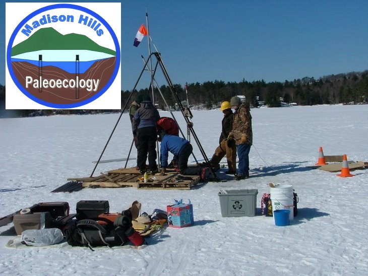
Preparations for tomorrow have been progressing well since we completed "round one" last Tuesday. We've been concentrating on modifying our equipment and material-handling processes to be more time efficient so we can get "more bang for our buck" while we're out on the ice. The major modification we've made is now visible to those of you in residence here on the Pond. You can look out at the drilling site and see the new tripod/come-along lifting system Russ Lanoie designed and fabricated for us in his shop down the road yesterday afternoon. We hauled it out to the platform and installed it this morning. We've tested in twice now and it performs very well with as much as 650-700 pounds "on the hook". It should ensure we can retrieve everything we sample tomorrow, an important factor now because the ice will shortly begin to become unacceptably thin.
So, we're off and running again. We'll get tomorrow's results posted as soon as we can.
Saturday, March 15, 2008
Social Posting #6
We're going with Monday, March 17, St. Paddy's Day, to core for a 2nd time to see if we can reach further down into the depths below where we left off last Tues. If you want to help or just observe we are starting to haul equipment out at 7AM and will go until we can't drill down any further. We can, also, use help at the end hauling the equipment off the pond. There may be refreshments at the site, but don't count on it since I don't know how many donut holes will be left from Tuesday or if Sylvia's delicious muffins are still uneaten. Hope to see you Monday.
Friday, March 14, 2008
Scientific Information Posting No. 10
DRILLING/SAMPLING ROUND 2 IS SCHEDULED
After some further confusion created by this winter's frequently-stormy weather pattern, we've scheduled the continuation of last Tuesday's drilling and sampling for next Monday, March 17th. We hope the "luck of the Irish" will prevail and we'll be able to complete the drilling down to the bottom of the Pond's basin that day. The weather is forecast to be fair with temperature around 40, so conditions will be right for the work. We left the drilling platform and outer casing in place out at the deepest spot last Tuesday evening, and we will reoccupy those facilities early Monday morning. As before, we'll get information up here on the blog as soon as we can after we complete what will likely be a long day on the ice.
If you'd like to get involved, we could use some help carrying equipment and supplies out to the platform in the morning and then bringing it back to shore in late afternoon ("many hands make light work"). Your help will be appreciated, especially by the "older backs" among us on the project team. There's nothing very heavy involved, just lots of it. Those who come along will undoubtedly become part of the project photographic and video record, and it is likely that some refreshment and nourishment may also be offered in thanks for the help (watch for the next "Social Posting"). If you'd like to volunteer, please give Betsy or Sylvia a call to let us know you're coming (447-5077 / 447-2333). Thanks in advance!
Thursday, March 13, 2008
Coreing Day Photos!
Click on the link below to view a slide show of pictures from Coreing Day, courtesy of Betsy Fowler!
Link to Coreing Day Photos
Link to Coreing Day Photos
Enjoy!
Orientation!

A friend asked for clarification of the location of the holes we have augered seeking the deep area. I made it confusing by orienting that diagram with North pointing downward, while most of the rest of our maps have North pointing upward. To clarify, here is a redraw of the ice fishing holes with North up, followed by a Google Earth map of the point showing the location of these holes. Hope that helps! ... Lee

Wednesday, March 12, 2008
Scientific Information Posting No. 9

A DAY OF "DEEP SURPRISE"
This is the first "quick posting" about yesterday's drilling and sampling work. Others with more detail will follow as each of us "physically recovers" from our respective labors out on the Pond.
We finally got to drilling and sampling yesterday under beautiful blue skies, light winds to start, and temperatures in the 20's most of the day (see photos to be posted here on the blog later today or tomorrow). We got started ferrying loads of equipment to the drilling site around 7:30 AM and had cleared everything except our drilling platform and deep casing from the ice by sundown. It was a lot of hard work, and I want to thank everyone who was involved, including those who braved the cold associated with standing around to video and photograph the process, which yielded some scientifically interesting and unexpected results.
We started drilling in approximately46 feet of water (the deepest spot in the Pond) and took multiple samples below the Pond-bottom to about 20 feet. The samples started off as loosely compacted, richly organic sediments that were somewhat surprisingly free of vegetative debris(leaf shards, pine needles, twigs, etc.), and while these organic-rich sediments became more well- consolidated ("stiffer") with depth, they continued to show this general composition right down to where we quit for the day.

We had not expected to find such an extensive thickness of strictly organic sediment, and in fact thought that by 20 feet beneath the Pond bottom, we'd have finished the drilling and sampling project after intersecting the several layers of much less organic sediment (combinations of sand, silt, & clay) that undoubtedly overlie the compact glacial till or bedrock that forms the Pond's basin. It's clear now that the Pond basin is significantly deeper than we thought, and we plan to continue the drilling and sampling as soon as we can reorganize ourselves for another round to "get to the bottom" of this unexpected situation. Depending on exactly how fast such organic material is deposited (thought to be about 3 feet per millennium...?), it's presently possible that we've penetrated something like 5,000 to 7,000 years of deposition and that we have another 4-5 to go before we get to the bottom of the basin that existed when the last glacial ice left it.
So, the project will continue. We'll keep you advised here on the blog of when we'll be drilling and sampling next. It has to be within the next 2-3 weeks, before the ice thins and can no longer support the drilling platform (and our equipment upon it). Keep your eye on the blog for other postings related to yesterday's activities, some of them with more detailed scientific information and others with observations and photographs of what went on out on the Pond.
Sunday, March 9, 2008
Social Posting #5
Just to update you all that the 9:30-11:30 refreshments and info session will take place on Tues., March 11 at the Pollock's as previously planned for 2 or is it 3 or 4? previous dates. Sylvia will be working, so I may be the only one at Pollock's while the rest of the crew are on the ice. In the event that I'm needed to help on the ice, I may have to lock the door and will leave a note regarding my whereabouts. So, if you should come and find the door locked that will be why. For those who are driving, you can park in the driveway of the house next door, the Gabrielson's, or on Spigot Hill Rd. If you plan to venture out on the snow on the pond you will need snowshoes so you don't sink in. As of today, there is a thick crust but it's not reliable to keep you from sinking all the time.
Saturday, March 8, 2008
Deep-Spot Quest…..continued!
We left off the saga of locating the deep area of the lake with an analysis of depths taken through holes left by the ice fishing folks. That map (viewed from the north - see earlier blog item) showed 2 holes at 42' depth, surrounded toward the top (south), left (east) and bottom (north) by shallower depths, leaving the right (west) side still to be explored.
With many thanks to Bob Denoncourt for the loan of his gasoline-powered ice auger, on Thursday, March 6, we added a series of 7 additional holes through the ice that have pretty well clarified where we need to core. The augering included an initial penetration of several feet of consolidated snow and frozen slush to a 6-10" layer offering virtually no resistance just above the surface of the ice itself (a phenomenon pointed out to me by the ice fishermen earlier). The thickness of the final actual ice layer is hard to measure accurately but it appears to be at least 10" thick. It's hard to tell directly since when you finish penetrating the ice, Big Pea Porridge Pond surges up and out of the hole at you – assisted by the auger's action. When the water level settles in the hole however, if I catch the bottom of a tape measure on the underside of the ice, the water surface in the hole is at 27". Apparently the ice with its snow-slush burden presses downward on the lake's surface, forcing the water to rise up well above the level of the actual ice cover when a hole is poked through it.* It makes it hard to estimate total water depth with precision – the top of the water level in each of these holes would seem to be artificially high with water released through the opening, but the bottom of the ice is probably an artificially low estimate of depth. To make results at least consistent with one another, depths on the attached map are based on 1 ft below the measured water depth in the holes.
Anyway, five holes were bored at intervals along an imagined transect line that runs from about the Gagnon's dock to the west to the south end of the Morton's house to the east – with the westernmost hole located on a line that runs about from the cleared vertical scar on Emerson's ledge to the south to the west end of the Stettner's house on the north. A second transect line with 2 additional holes runs from the outlet to the south to the Davis house on the north. The attached map shows the adjusted depths recorded within this area. NB: I've adjusted the estimated depth at the "original holes" from the previous survey upward by a foot – using the "1 ft below the water depth in the hole" strategy described above (as opposed to the 2 ft below standard I used then).
As you will see on the map, there is an area of ca. 50 ft x 50 ft measuring a consistent 43.2 ft depth. Given the phenomenon of annual deposits of fine sediments raining down on the lake bottom filling in deepest part of the underlying lake basin over time, finding a more or less flat floor of sediment makes sense (imagine sediments settling to fill in the bottom of a tapered beer glass). Over time, with more and more sediments, one would expect the area of this flat spot to expand.
Above, I've offered visual reference lines to help you locate this area on a map or when you are paddling on the pond. Actually, you might also find the contour map available on the NH Fish & Game website (and also posted on the blog) or at the VLAP website to be useful. The problem there is that while their pond outline is accurate, their location of the deep spot and of the grassy island is badly inaccurate (for example, note the location of the grassy island in the pond visible on the Google Earth map relative to its location on the VLAP map). I've found that to more correctly locate both the island and the deep spot on their map: on a second sheet, make a tracing of the lakeshore outline from the VLAP map and line it up on top of the original VLAP map with depth contours. Place a pin through both maps at the top (north) tip of the island (= "peninsula"), to act as a pivot point, and rotate the left side of the bottom map upward by 28o. That will place the location of the island and deep spot properly to be traced onto the top lake outline map! Wonder who screwed up in making the original?

* This adds evidence to the earlier hypothesis that the standing water layer on the ice surface came from pond water (not so much from rain water) forced up through ice fishing holes. Anyone else noticed this standing water layer on top of the ice this year or in the past? Does water routinely surge up and out of holes poked through the ice (especially when NOT using a mechanized auger which exaggerates the initial surge), suggesting a release of pressure on the underlying water? The question is, does this "routinely" occur in winter, or is it the result of the record-making snowfall on the lake's surface this particular winter? Also, if this is the case, is the actual surface of the ice concaved slightly out toward the center (i.e., is the standing water layer under such circumstances deeper toward the center of the lake)? Finally, what effect might added water pressure generated in this way have on internal water movements, e.g., sub-ice currents flowing, for example, toward the outlet (or any other spot of lowered resistance, such as an ice fishing hole)? Normally, lakes under ice cover are rather stagnant since the wind contact with the surface – the usually dominant force in generating lake water movements – is sealed off by ice. This lack of circulation in winter is what often leads to low or no dissolved oxygen in deep spots because once oxygen there is consumed by decomposition of organic matter or in various other chemical reactions, there is limited water movement to replenish it and diffusion from oxygenated surface waters is too slow. ..... Lee
How To Use This Blog To Become Involved
FOR THOSE UNFAMILIAR WITH "BLOGGING"
We've noticed that there have been hardly any comments or questions submitted on this blog through its "Comment" function. This quick note is to let you know how easy it is and to encourage you all to participate by "commenting".
We're really interested in what you think about the project and would love to answer your questions, consider your suggestions, and enjoy your opinions on such things as: (a) what we're doing, (b) how we're doing it, (c) the results we get, (d) their scientific interpretation, (e) the history of the Pond as you know it from various points of view (not just scientific), (f) your experiences with the kind of things we're doing, (g) climate change and related paleoecology, and (h) anything other subject you think may be of interest to the others reading the blog. We know there are many readers on the blog (we've heard from many of you by email and telephone), but we think what you think would be of interest to all the others.
So, if you want to comment on any of the postings so far added to the blog, just click on the line marked "comments" in the lower right corner below the posting. This will take you to a page with a blank box in which you type our your comment or question. When you're finished, scroll down through the rest of that page, adding the information it calls for as you go (although you don't have to set up a Google Account; just by-pass that if you wish), and then click the "Submit" button at the bottom. Your text will be automatically posted onto the blog at the end of the particular posting your commenting upon.
Then check in on the blog periodically to see who responds and how. If you want a specific person from the project to respond, just mention one of our names and we'll do it. It's really very simple, and the exchange of information gets to be a lot of fun. Don't be afraid because your not "scientifically qualified" or technically inclined. Very often the simple questions from folks not familiar with the science actually better help everyone understand what's going on. You can even use an alias if you want to remain anonymous. Naturally, though, we'll all try to figure out who you may be anyway.
So, let us hear from you, and we all have some fun. We've been amazed at the wide range of folks interested in what we're doing on this unique kind of project. It's "citizen science" at its best.
Scientific Information Posting No. 8
DRILLING & SAMPLING IS FINALLY "ON"
This posting is to confirm that the drilling and sampling activities will (finally) take place this coming Tuesday, March 11th. The weather forecast models have given us a nearly certain"fair/warm (mid-30's) window" in the stormy pattern, and everything is ready to go. The only weather-related uncertainty now is how much standing water we'll have to contend with after today/tonight's +/- 1.5 inches of rain/freezing rain. However, we'll have all-day Monday to respond to this, so don't see it as "killer" at this point. The Project Scientific Staff have all consulted in the past day or so, and all the equipment and supplies needed are on hand and ready, both at the drill site and at the Pollock beachhead.
The last pieces came together yesterday afternoon and evening when Lee and Brian finished "inventing" the connection scheme for the special, garage-fabricated drill casing system we'll use (created from perforated PVC drain pipe), and then acquired 100 feet of replacement cable for the sampler and 10 feet of small-diameter solid PVC pipe to specially prepare "split tubes" for receiving and safely storing the samples - all before being kicked out of Lowe's at its closing time. The PVC casing system design is a real "original" and we are anxious to see if it works as well as we believe it may. If it does, it will be another ancillary contribution of our project to paleoecological science (we will see...).
Anyway, all of the "grunt science" work is now complete and the exciting part about to begin. We'll get information here onto the blog as soon as we're able after Tuesday. Meantime, please ask for intercession on our behalf by the forces that govern the weather.
Thursday, March 6, 2008
Okay. Brace yourself!
The updated weather forecasting models for this coming weekend spell
disaster for our coring project once again. (For more, see Brian's
posting at the blog). A first wave of precipitation will wipe out
Friday night into Saturday, and a second wave will do the same for
Saturday night well into Sunday. The veteran core samplers amongst us
assure us that the work involved is hard enough in decent conditions.
To perform all the hand-work required it in a cold, pouring rain or
through a coating of freezing sleet is just too much. So once again, we
are reluctantly postponing the coring from this Sunday.
As March marches on, we begin to be concerned about our window of
opportunity for getting this critical work done while the ice cover
remains sufficiently safe. (NB: There is plenty of solid ice at the
moment – see the latest report at the blog on ice augering to
determine the location of the "deep spot"). But as a result, we are
grabbing the very next set of hopeful weather conditions and are
rescheduling the coring work to this next Tuesday, March 11 –
cognizant that this will exclude participation by those holding down
REAL jobs! Sorry, although we hope to be able to video-document the
work for subsequent viewing!
Encouraged by the interest of surrounding friends from all sorts of
fields of interest, we've been trying to keep you abreast of the
step-wise development of this project as a way to illustrate not just
the eventual outcomes of science, but also to give a taste of how
scientific information is actually gathered. For those of us engaged in
"field" science, the sort of weather dependent frustrations and constant
adjusting of plans that you are witnessing here are all too often the
reality that we live with. Jacques Cousteau was lying to you by
presenting a picture of field sampling that always ends in a warm sunset
with ze red wine on ze fantail of ze Calypso! There is a reason why the
scientific study written up as a final journal paper SOUNDS as though it
should have taken about 4 days to perform, and yet, it is the result of
a 2 year grant! By being part of our conversations and experiences
here, maybe you can begin to see why! Please stick with us! The really
exciting parts lie just ahead.
Lee & Brian
Scientific Information Posting No. 7
DRILLING & SAMPLING POSTPONED AGAIN
The unusually frequent pattern of significant winter storms affecting the region has again made postponement of our field activities necessary. Thus the drilling and sampling, along with the associated social activities, scheduled for Sunday, March 9th are cancelled. Current weather models call for a two-pronged winter storm starting later Friday evening and into Saturday afternoon followed by a second pulse of sleet, freezing rain, and rain into mid-day Sunday. The forecasts suggest significant icing (up to 1/2 inch) is possible during both pulses, so manipulating the drilling and sampling gear would be very difficult if not downright dangerous.
In response to this cancellation, we have checked the forecasts for a possible window in this storminess during which to get the field work completed. Right now, such a window appears available for about 48-60 hours starting late Sunday. During this period, mainly fair weather is forecast with daytime temperatures in the mid-30's to lower 40's; much more suitable for our field operation. So, the drilling and sampling work has been rescheduled to take place on Tuesday, March 11th.
We realize this is during the week and many will not be able to visit during the work, but given the uncertainty of the weather so far this year and the fact that soon the ice on the Pond will start to thin, we decided to take advantage of this "window" to keep the project's momentum going into the Spring as planned.
So, unless the weather again interferes, the next Scientific Information Posting should be made just after the field activities are completed, probably March 12th or 13th (after we warm up and dry out...).
If you have any questions or comments, please add them to the comments section below.
Wednesday, March 5, 2008
Coring Re-scheduled to Sunday 9th
We continue to struggle with this winter's bizarre weather patterns! Amidst freezing rain as I speak, we are eyeing a not-so-nice forecast for the upcoming weekend. Here is the plan:
- We will NOT be conducting the coring on this Saturday, March 8 after all. The weather conditions are just hopeless for that day.
- We HOPE that the weekend storm will clear to permit us to core on this Sunday, March 9 instead. (Unfortunately, current weather models suggest the storm may spill over Saturday night and into Sunday and may force us to postpone the event even further).
- IF we are unsuccessful and have to cancel coring this weekend entirely, then the coring will take place the FOLLOWING Saturday, March 15.
Please watch here for up to the minute scheduling and adjustments -- including information about Sunday.
Sorry to need to hold our plans "up in the air" like this!!
Lee
Monday, March 3, 2008
Social Posting #4
In case you have forgotten the activities that were previously scheduled for the GPR survey that will be rescheduled for this coming Saturday, beginning at 9:30 and until 11:30 refreshments-Leavitt's donut holes, coffee, tea, hot chocolate- will be served at the Pollock's house on Allard Hill Rd. Also, there will be updated info on how the coring is going and what they have been able to "see" of the samples taken, how many feet of core has been removed, how they prepare it for storing and how it will be stored, among other exciting developments. We will have Madison Hills Paleoecology logo patches on fleece hats and baseball caps for sale to benefit the project. We can also arrange with New England Embroidery to get these patches sewn onto your own hats, jackets, shirts, or whatever. Be on the scene with your friends and neighbors as the drilling news breaks. Hope to see you there. Call Betsy @ 447-5077 or Sylvia @ 447-2333 for last minute questions, or post comments to this blog.
Saturday, March 1, 2008
Scientific Information Posting No. 6
A quick note to let everyone know that things are "on-schedule" for the drilling and sampling to take place this coming Saturday, March the 8th. We will be preparing the drilling site and the logistics "beachhead" on the Pollock's shoreline on Friday, March 7th, and activity should begin fairly early on Saturday morning with the intent of completing the drilling and sampling in a bit of a long day on Saturday. Barring some kind of major tempest (we are carefully monitoring the longer-range weather forecast), a complete thaw of the Pond, or the return of the Laurentide Ice Sheet, we will complete the first step of the project very soon.
More detailed schedule information will appear here in the next several days, so keep tuned. Meantime, the social activities are also on-track (see below).
More detailed schedule information will appear here in the next several days, so keep tuned. Meantime, the social activities are also on-track (see below).
Subscribe to:
Posts (Atom)